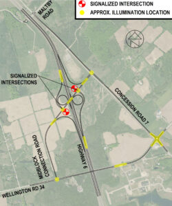
This image is a map illustrating the road network and traffic infrastructure in a specific area near Highway 6. It highlights signalized intersections and approximate illumination locations.
Roads Displayed:
Maltby Road
Concession Road 7
Highway 6
Midblock Connection Road
Wellington Road 34
Key Features:
Signalized Intersections: Indicated by red circles with white crosses, located at major junctions.
Approximate Illumination Locations: Indicated by yellow circles, placed near intersections and along key road segments.
Orientation and Relationships:
The map is oriented with north at the top.
Roads intersect at various points, with signalized intersections primarily at major crossings.
Illumination points are distributed to enhance visibility at strategic locations.

