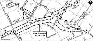
This image is a detailed map outlining the study area for project GWP: 3042-14-00 in Puslinch, Ontario. The study area includes a network of roads and highways:
Highways: Highway 401 and Highway 6.
Regional Roads: Wellington Road 34, 35, 46.
Local Roads: Maltby Road W., McLean Road, Leslie Road W., Concession Road 1, Concession Road 7, Fielding Lane, and Gore Road.
The map also features CP Rail, which runs parallel to some of the roads. Directional indicators point to nearby cities:
North: Guelph
East: Toronto
West: London
Southeast: Hamilton
The study area is clearly marked, providing geographic context for transportation planning or environmental assessment.

