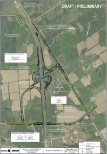
This is a draft/preliminary map illustrating proposed changes to a highway interchange and surrounding road infrastructure in the Wellington Road 34 area. The map includes both geographic layout and structural cross-sections.
Key Features and Labels:
New Emergency Turnaround north of Kaltey Road.
Access Removal: Highway 6 ramp access at Taylor Road and Concession Road 1 will be removed.
New Cul-de-sac on Concession Road 4.
New Bridge: Wellington Road 34 Connection Road Bridge.
Block Linking Road: Wellington Road 34 Block Linking Road.
New Infiltration Basin: for stormwater management.
New Roundabout: at Wellington Road 34 and Concession Road 7.
Existing Fuel Station Turnaround will be maintained.
Legend:
Proposed Right of Way (ROW) – marked areas for future road development.
Existing ROW – current road boundaries.
Orientation and Relationships:
The map is oriented with north at the top.
Roads, bridges, and infrastructure elements are labeled clearly.
Proposed features are visually distinguished from existing ones using color and line styles.
Cross-sectional diagrams show bridge design details.

