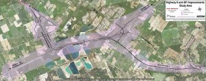
This map outlines the study area for proposed improvements to Highway 6 and Highway 401. Key features include:
Labeled roads such as “New Highway 6,” “Highway 401,” and “Wellington Road 34.”
Intersections and road segments are clearly marked.
Shaded regions indicate the boundaries of the study area where infrastructure changes are planned.
A legend in the top right corner provides context and includes logos for AECOM, the Ontario Ministry of Transportation, and other relevant organizations.
The map is oriented to show the geographic layout of the highways and surrounding roads, aiding in understanding the scope and location of the proposed improvements.

