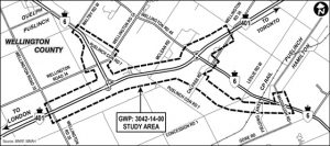
This image is a detailed map of a study area located in Wellington County, Ontario, Canada. The study area is outlined with dashed lines and labeled “GWP: 3042-14-00 STUDY AREA.” Key transportation routes are marked, including:
Highways: Highway 401 and Highway 6.
Local Roads: Wellington Road 34, Puslinch Concession Road 1, Leslie Road, and Gore Road.
Directional markers indicate proximity to nearby cities and regions:
North: Guelph
South: Puslinch and Hamilton
West: London
East: Toronto
The map provides geographic context for infrastructure planning or environmental assessment within the designated study area.

